
One of the biggest surprises about Northwest natural history is that there were many catastrophic floods during recent geological times that dramatically altered the landscape of Washington state. Almost half the state was inundated. This hypothesis was first put forward by geologist J Harlan Bretz in the 1920s.
These floods are thought to have swept through the state many times during periodic ice ages. During the last ice age, a lobe of a Canadian glacier blocked the Clark Fork River drainage in Idaho, causing glacial meltwater to fill up the valleys of the Mission, Bitteroot and Rattlesnake Mountains to form Glacial Lake Missoula, estimated to have been 3,000 square miles. High above Missoula, along the mountain slopes, there are strandlines of many prehistoric lakes. More than once, when the water level became high enough, the ice dam would be breached and let loose 500 cubic miles of water in 48 hours, a cataclysmic megaflood that drained to the southwest into eastern Washington, down through the Columbia gorge, into parts of western Oregon, even extending as far south as Eugene, and out to the Pacific Ocean via the Columbia River. At one time, present-day Portland was buried under 400ft of water. It is estimated that the flow rate was ten times greater than all of the world’s rivers combined. The onrushing deluge carried with it not only unimaginable amounts of water and debris but enormous boulders, some rafted on icebergs over hundreds of miles before being deposited (glacial erratics). The Willamette Valley in Oregon has erratics up to 40 tons. These repeated inundations stripped off the topsoils of eastern Washington to lay bare the hard basaltic layers underneath (from previous volcanic lava flows as early as 17 million years ago) that earned this area its name, the channeled scablands (coined by Bretz). To this day, after many thousands of years, you can still see evidence of the flood(s).
The scablands would not be as spectacular if not for the basalt layers. One common form that appears in the Northwest is columnar basalt, vertical cracks forged in the basalt layers as they cooled very slowly. Less resistant to erosion is basalt entablature, usually on top of columnar basalt, that has cooled more rapidly and therefore don’t readily form clean vertical cracks but show a more random fracture pattern. When monstrous floods attack these layers, columnar basalt can more easily be plucked away, leaving behind steep, vertical channels in the landscape, called coulees. Most coulees are dry, unlike canyons that still have rivers flowing in them.

My wife and I set out on a road trip to see firsthand some of the spectacular evidence that these floods left behind. I picked out a few important sites that we could fit into a three-day trip. Going by car is a great way to visit these places, especially with the help of references such as Bruce Bjornstad’s classic book as a guide. This book
Our first stop was an overlook just outside Quincy. A short half-mile hike to the edge of Babcock Ridge gave us a stunning view of the resort of Crescent Bar over 600ft below and giant flood-produced current ripples on a bar across the Columbia River. These ripples are gigantic in scale, about 20-50ft high and spaced over 300ft apart, estimated to have been submerged under 600ft of water. At that height, the waters overtopped portions of the ridge that we were standing on, carving out the gigantic Potholes Coulee just to the south.

Another phenomenon that fast-moving water creates are potholes. High-energy tornadoes of water (or kolks, as they are called) tore out huge holes in the bedrock, sometimes more than a mile wide. Some are now lakes and ponds, but most of them are dry. There are many examples of this, including the gigantic one we saw north of the Frog Lake trailhead on Morgan Lake Road in an area called the Drumheller Channels and the lakes below Dry Falls.

Drumheller Channels are an amazing network of interconnected, braided channels that were sculpted out of the earth by the deluges from the northeast. Below is a panorama that I spliced together from seven photos taken along our drive on Morgan Lake Road.

As dramatic as the landscape looked from the road, we just couldn’t visualize what this area looked like from above. With the help of Google Earth, it can clearly be seen. This area was unique enough that it was designated a National Natural Landmark by the National Park Service.

Along the northern shore of Lake Lenore are a series of caves that were carved out by the swirling flood waters, plucking out the looser columnar basalt more easily than the more resistant entablature above it. You can see them as you’re driving along Hwy 17. A turnoff for the attraction leads to a parking lot where the trailhead is located. Beyond the stone staircase up a short distance, the trail divides to the left and right. Some of the caves were large enough for prehistoric people to have used as shelters.

Further, just before Coulee City, is Sun Lakes-Dry Falls State Park, an area used for recreation and a showcase for observing the handiwork of ancient floods. Spanning 3.5 miles wide and averaging 400ft in vertical drop, Dry Falls is the remnant of the largest falls that the world has ever seen, ten times the size of Niagara Falls, but now a dry cataract. You can try to envision this cataclysmic spectacle from the Dry Falls Interpretive Center on Hwy 17, two miles north of the main park entrance. (Un)luckily for us, the center was closed for the entire day due to staff meetings. But, the overlook is open year-round (weather permitting). From here, you can gaze at the immense cataract and the plunge pools, now lakes and ponds, that the waterfalls created.


As we drove past Ephrata toward Moses Lake on Hwy 17, we couldn’t help but notice the vast flood plain littered with boulders. When the flood waters broke free from the Grand Coulee, they spread out into the Quincy Valley and deposited these boulders knocked free from the Grand Coulee and sources upstream, some as high as 60ft. This area is known as the Ephrata Fan, an expansion flood bar, where there is little productive farming.

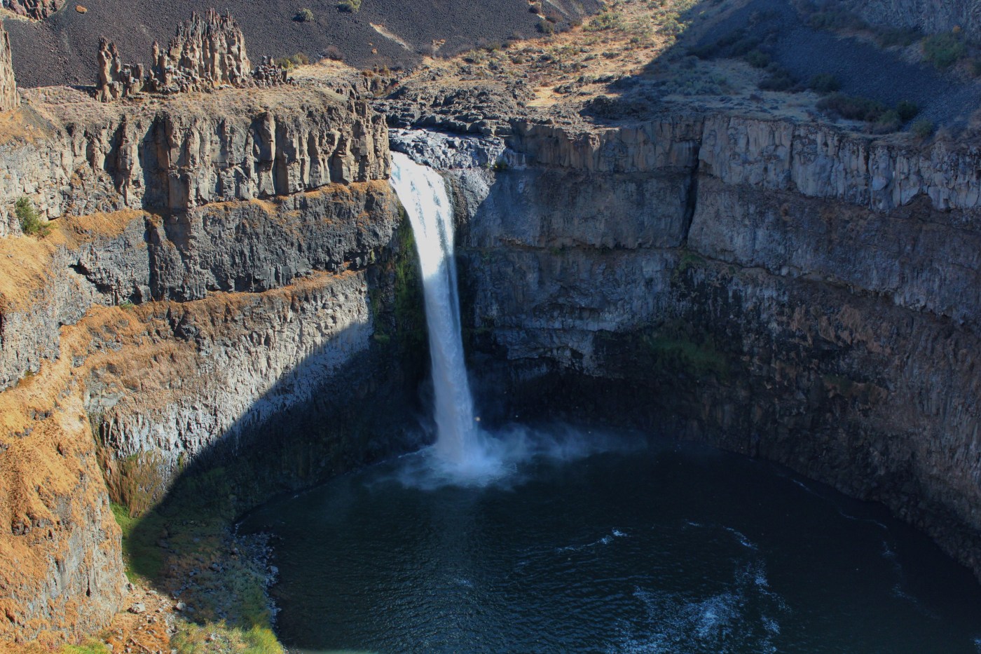
While almost all flood-cut waterfalls in the channeled scablands are now dry cataracts, there is one that remains, a whisper of its former self, but spectacular nonetheless. Palouse Falls flows year-round, but its most impressive displays are during spring melt when the volume is greatest. At the foot of the falls is a large plunge pool. The falls are part of the Palouse River system, which continues through the breathtaking Palouse River canyon downstream to join the Snake River. Unlike typical canyons, these coulees were sheared by the ice age floods.
The best place to see it is at Palouse Falls State Park, accessed by a spur road from Hwy 261, 17 miles from Washtucna. We enjoyed a picnic lunch here (there are nice picnic tables) and hiked a trail that hugged the edge of the coulee, including one that led to a very narrow ridge directly above the pinnacles to the left of the falls.


This illustration by artist Stev Ominski dramatizes what the event probably looked like.

Interestingly, ninety percent of Washington’s vineyards are planted in soil deposited by or as a consequence of the ice age floods. Almost all the silts and minerals that used to cover the scablands got stripped away and laid down in the Columbia and Walla Walla valleys where the state’s finest vineyards are located. The Willamette Valley in Oregon, known for its pinot noir, also has soil similar to that from Lake Lewis, the temporary 1,200-foot flood-produced backwater lake that rose behind Wallula Gap in eastern Washington and covered the Tri-Cities area (Pasco, Richland and Kennewick).
Only three days long, our road trip was certainly not comprehensive enough to see even a fraction of the geological evidence of a megaflood. But, with a new understanding of what took place, I will never look at eastern Washington with the same eyes as before. It was worthwhile and humbling to take the trip.
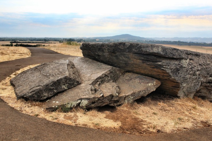
Update (8-4-15): Lying between McMinnville and Sheridan near Oregon’s Highway 18 are glacial erratics that were left behind by one of the Missoula floods. Erratic Rock State Natural Site showcases a 36-ton argillite specimen that is presumed to have been encased in an iceberg that got rafted by a flood and deposited here when the water receded. It is the largest erratic in Oregon. What makes this particular set of rocks so unusual is that they came from Canada, the only ones known to have traveled beyond our neighbor’s borders.


Thank you for sharing your Missoula Floods trip pictures & comments. I learned a lot from you in a short period of time. Your writing style is quite readable. I found this while trying to find information on my own upcoming trip to trace the path of the floods from Missoula all the way to the coast. Now I’m even more excited about the trip!
LikeLike
Ketti, thank you. I’m glad you find the post useful. If you can, be sure to refer to Bjornstad’s book that I mentioned. Another good reference is the Ice Age Floods Institute’s website (http://www.iceagefloodsinstitute.org/index.html). Best of luck on your upcoming trip.
LikeLike